CAPTAIN SEAGULLS CHART NG12, NANTUCKET SHOALS, GEORGES BANK
September 10, 2014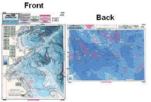
CAPTAIN SEAGULLS CHART IC209, STELLWAGON BANK TO WILDCAT/CASHES LEDGE
September 10, 2014
CAPTAIN SEAGULL CHART OF10, NANTUCKET SHOALS TO MID LONG ISLAND, NY, NE CANYONS
$21.99
Offshore – 90 to 100 miles off coast, Double sided, laminated, 19 x 26 inches. MA, RI, CT, & NY.
Front: from Nantucket Shoals to mid Long Island, NY south to cover all canyons beginning with the Veatch Canyon to Hudson Canyon.
Back: a blow up of the very important fishing spots off Block Island Sound, including the Dump, The Finger’s Cox’s Ledge and many more. You don’t have to purchase both the OF10 and the OFGPS18 unless you are going south to New Jersey.
Reviews
There are no reviews yet.